オリジナル英文URL:Blizzard Bears Down on U.S. East Coast
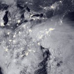
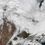
NASA-NOAA’s Suomi NPP satellite snapped this image of the blizzard approaching the U.S. East coast around 2:35 a.m. EST on Jan. 22, 2016 using the Visible Infrared Imaging Radiometer Suite (VIIRS) instrument’s Day-Night band.
Image Credit: NOAA/NASA
Last Updated: Jan. 23, 2016
Editor: Sarah Loff
NASA-NOAAスオミNPP気象観測衛星は、可視赤外放射計画像装置(VIIRS)の昼夜測定帯域で2016年1月22日2:35(アメリカ東部標準時)に米国東海岸に接近するブリザード撮影したのがこの画像です。